Argo: the robotic floats that take the ocean's temperature, and the cooperation behind them
Most of the heat trapped by greenhouse gases ends up in the ocean, yet until the early 2000s nobody could say with confidence how warm the upper ocean was over most of its surface, because ships rarely went there. Today a fleet of small robotic floats, drifting in every ocean basin, sends back a temperature and salinity profile every few days. The Argo programme is one of the most successful research infrastructures ever built, and it has no headquarters, no single owner and no central budget.
A float that sinks, drifts and rises
An Argo float is a cylinder one to two metres long, with an antenna at the top and a bladder at the bottom. By pumping oil between an internal reservoir and that external bladder, it changes its volume, and therefore its buoyancy, so it can sink or rise without a propeller.
According to the programme's own description, a typical cycle goes like this. After deployment, the float sinks to a parking depth, usually about 1 kilometre, and drifts with the currents. About ten days later it descends to 2 kilometres, then rises to the surface, measuring temperature, salinity and pressure on the way up. At the surface it transmits its profile and position by satellite, then sinks again and repeats the cycle until its batteries run out. In 2024, the array was collecting about 13,000 profiles a month, more than 400 a day.
The name is a reference to Greek myth: Argo was the ship of Jason, and the programme was designed to work alongside the Jason series of satellite altimeters, which measure the height of the sea surface from space. Satellites see the surface, floats see what lies beneath it, and the two together describe how the ocean stores and moves heat. Our explainer on space technology and the SDGs covers the orbital half of that partnership.
Built by countries, not by an organisation
Argo began in 2000. Its organisation is unusual for a global infrastructure. There is no central fund: each of the roughly thirty countries that operate floats pays for its own floats, their deployment and the processing of their data. The programme estimates the total cost at at least 40 million US dollars a year, with a single float costing between 25,000 and 185,000 dollars depending on its sensors. An international steering team sets technical standards and coordinates the effort, and Argo is part of the global ocean and climate observing systems run under the auspices of UN agencies.
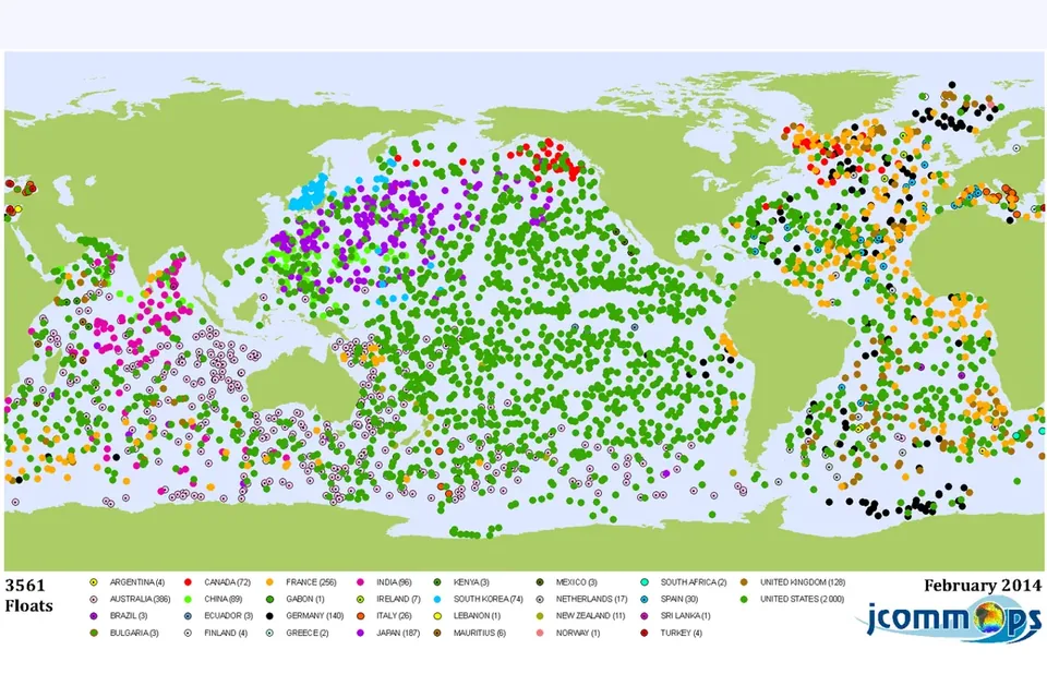
The map above, drawn in February 2014, shows what this looks like in practice. The United States owned about 2,000 of the 3,561 floats active at the time, followed by Australia, France, Japan, Germany and the United Kingdom, but dozens of other countries contributed from one float to a few dozen, from Kenya and Mauritius to Ecuador and Lebanon. A small contribution still buys a seat in a global system whose full output is available to every participant.
The original target was an array of about 3,000 floats spread across the open ocean. Covering the polar regions and marginal seas raises that target to about 3,800. Newer designs extend the mission in two directions: Deep Argo floats profile far below 2,000 metres, into the deep ocean that the original design could not reach, and BioGeoChemical Argo floats carry extra sensors for properties such as oxygen, nitrate, pH, chlorophyll and light.
Data that are free, fast and checked twice
"A fundamental rule for Argo is that all data are freely and openly available," the programme states. Most profiles are meant to reach users within about 12 hours of the float surfacing, quickly enough to feed weather and ocean forecasting models. These real-time data pass automatic quality checks only. Later, scientists compare each float's measurements with those of nearby floats and research ships, correct sensor drift where needed, and replace the real-time values with "delayed-mode" data suitable for climate research.
This two-speed system is a practical answer to the tension at the heart of open science between speed and reliability, discussed in our explainer on the UNESCO Recommendation on Open Science. It has paid off: the programme counts more than 6,000 scientific publications and almost 500 doctoral theses that used Argo data.
Argo combines national ownership of the hardware with a shared rulebook and fully open data. No country could afford the whole array alone; every country can use all of it.
When a float drifts into someone else's waters
Floats go where the currents take them, and the ocean is not legally empty. Under the UN Convention on the Law of the Sea, marine scientific research in a coastal state's exclusive economic zone normally requires that state's consent. A fleet of autonomous instruments that nobody steers fits awkwardly into that framework.
The answer was negotiated at the Intergovernmental Oceanographic Commission of UNESCO. Its Assembly's Resolution XX-6, in 1999, concluded that coastal states must be informed in advance of deployments that might drift into waters under their jurisdiction. In 2008 the Executive Council adopted guidelines (Resolution EC-XLI.4) for floats deployed on the high seas: they confirm that Argo must be fully consistent with the Convention, "without prejudice to the sovereign rights of the coastal States", and organise notification through national focal points and the Argo Information Centre, set up by the IOC with the World Meteorological Organization in 2001. It is an example of the quiet diplomacy that shared science depends on, comparable in spirit to the arrangements that let GBIF pool species records across borders.
What Argo does for the SDGs
- SDG 13, climate action. Argo profiles are a backbone of estimates of ocean heat content, sea-level rise from thermal expansion and changes in salinity that trace an accelerating water cycle. Climate assessments rely on them for the period since the array became global in the mid-2000s.
- SDG 14, life below water. Target 14.3 asks countries to minimise and address ocean acidification, and its indicator relies on measurements of marine acidity. Biogeochemical floats measuring pH and oxygen extend those measurements to regions and seasons that ships rarely sample.
- SDG 14.a and SDG 17, knowledge and technology. Target 14.a calls for increasing scientific knowledge, developing research capacity and transferring marine technology. Because the data are open, forecasting centres and universities in countries that own no floats at all can use the full array.
The limits
Argo is not a complete picture of the ocean. Coverage is thinner under sea ice, in shallow coastal waters and in marginal seas, which are precisely the places where many coastal communities live and fish. Most floats are not recovered at the end of their life, which raises questions about waste at sea. Above all, the array depends on dozens of national budgets renewed year after year: a few countries reducing their contribution would leave holes in the map. The UN Decade of Ocean Science for Sustainable Development, running from 2021 to 2030, has made sustained ocean observation one of its themes, but sustained funding is still decided capital by capital.
That fragility is also the lesson. Argo shows that a global infrastructure can be built from national pieces, provided the rules on standards, data and access are shared from the start. It is SDG 17 in hardware form: a partnership that delivers a public good no single partner could have produced alone.
Sources and method
- Argo programme, About Argo (float cycle, profiles per month in 2024, number of countries, costs, data policy and timing, publications) and its page on the expansion of the array (target of 3,800 floats), consulted on 9 November 2026.
- Intergovernmental Oceanographic Commission of UNESCO, Resolution EC-XLI.4 (2008), guidelines for the implementation of Assembly Resolution XX-6 on the deployment of profiling floats.
- UN Statistics Division, SDG indicator framework (targets 14.3 and 14.a). Float numbers by country: JCOMMOPS map for February 2014 shown above.
 Research infrastructures
Space technology and the SDGs
Earth observation, navigation and communications satellites, the UN framework behind them, and the risks of crowded orbits.
 Cooperation and skills
Open science and the SDGs
The 2021 UNESCO Recommendation, its seven areas of action, FAIR and CARE data, and who pays for openness.
 Research infrastructures
GBIF and open biodiversity data
An intergovernmental network that pools where and when species were recorded, what its 3.9 billion records contain, and what they miss.